There are in principle four types of local authority, though within each typology there are marked differences.
They are:
- County Councils
- District and Borough Councils,
- London Boroughs,
County, District and Borough Councils have sometimes been amalgamated into:
- Unitary Authorities, including ...
- Metropolitan Councils
The House of Commons has published a very helpful briefing paper on unitary local government.
In addition, within more rural areas, there is a lower tier of Town and Parish Councils.
County Councils
County councils generally cover larger geographical areas, examples would be Cornwall, Warwickshire and Essex. From Kent County Council with the largest population (2018) of over 1.5million to Cumbria with smallest population, .42 million. However, when geographical size is accounted for North Yorkshire with 8083 square kilometres is largest to Buckinghamshire with 1043 square kilometres is smallest. However, Hertfordshire has the highest population density of 721 people per square kilometre making it most density populated in England.
As administrative areas many have been in existence for over a millennium tracing their history back to localities that the crown could call upon for taxation and the raising of armies. This historical perspective must not be underestimated in the minds of the public as they can define very strong local associations and be significant in creating local and regional identities.
In addition to the above the previous fifteen years or so has seen the creation of what are termed ‘Unitary County Councils’ – as a simple explanation they are local authorities that have maintained their geographical boundaries on the whole but absorbed the roles, functions and services of District and Borough councils that were contained within their boundaries.
District and Borough Councils
(N.B to all intents and purposes these are very similar. Certain ancient authorities have retained ‘Borough’ status – a term that reflects the granting in ancient times by a monarch the right to a self-governing walled township)
In England there are 192 district councils (some still called borough councils) which vary greatly in land area, Torridge (Devon) is the largest at 984 square kilometres and there are many of less than 100 square kilometres; examples being Stevenage with 26 square kilometres and nearby Harlow with 30 square kilometres.
One important aspect to the district council is that it can serve as a way of offering distinctiveness to a locality, whilst larger geographical areas (Counties) have significant local variations within them one key argument for District councils is that they define place. Later, we will explore the complex issues of how local government is financed but in two tier areas the role of the District council as the collector of taxes is paramount.
Metropolitan Councils
Larger urban and industrialised areas and the larger cities in England are covered by Metropolitan councils, there are 36 such councils mostly based on large city areas and regions. Examples are Sheffield, Newcastle upon Tyne and Liverpool City Council. However, areas such as Kirklees cover agglomerated areas of West Yorkshire around Huddersfield and the heavy woollen district as it was known and Trafford forming as large area to the south of Manchester. What is key to these authorities is that are single tier or ‘unitary’ in function. Whilst the counties contain the district and Borough councils these metropolitan councils encompass all the functions that each of the others do.
Other English Unitary Councils
To further complicate matters, other unitary councils have been introduced in England since the late 1900s. These combine what were formerly County, District and Borough Councils.
These have taken slightly different forms, for instance following a government review the county of Northumberland became a unitary county on abolition of the districts it contained and Wiltshire also. The review of 2008 of Cheshire took a somewhat different approach in the creation of two unitary councils out the original two-tier approach there, the creation of Chester and West Cheshire and East Cheshire as two unitary councils was seen to be the most effective solution. Whilst there are clear economic reasons why such reorganisation take place, not least being the economies of scale that can be created but as the populations of locations change there is a requirement to manage the local governance and administration in a way that reflects this. As of 2020 there are suggestions of further change and reform to the administrative map of England reflecting the needs of local people.
This map shows the unitary councils, before the mid-2020s reorganisations (see further below) and which of these have mayors.
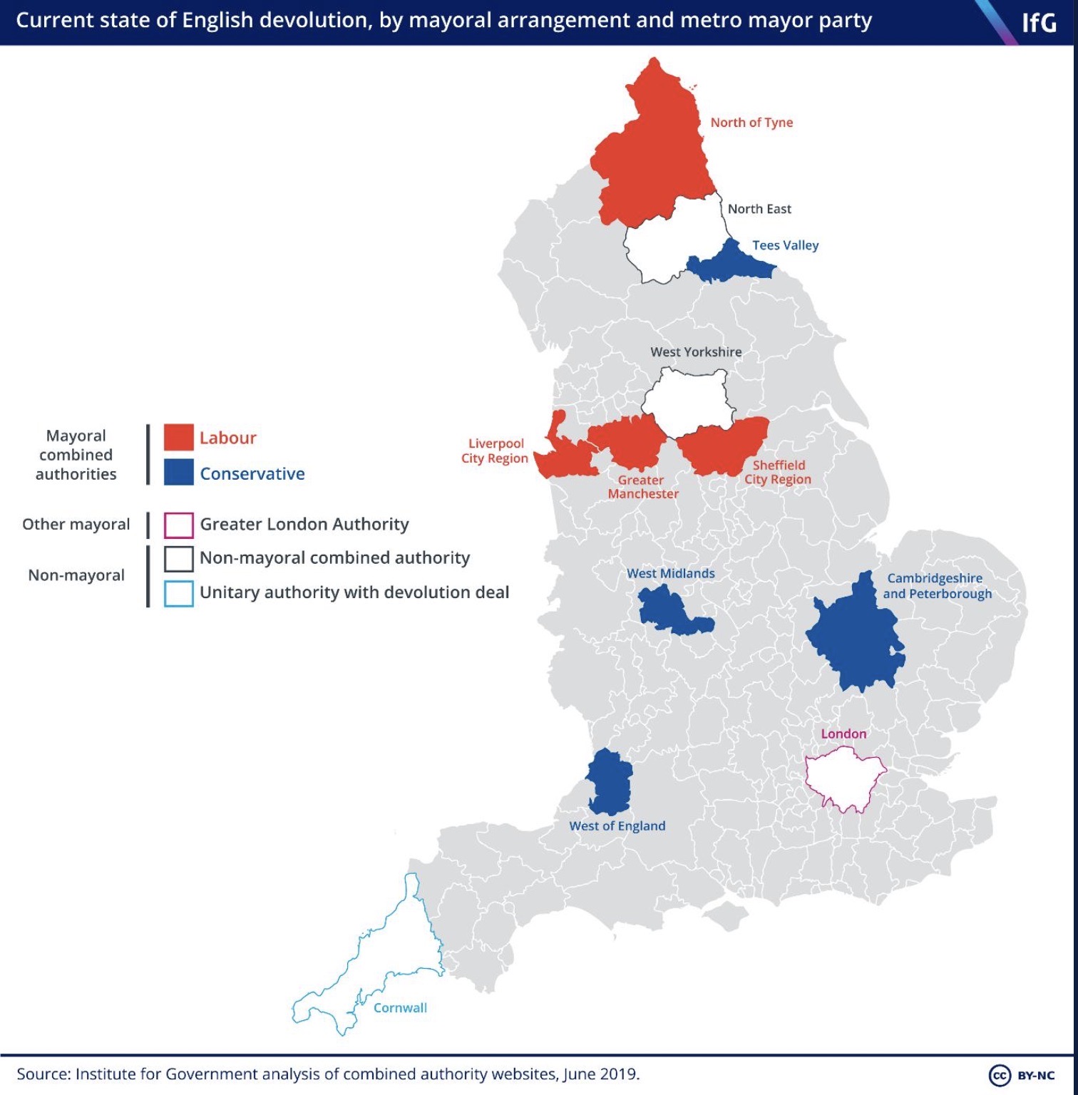
(Please note that the Cambridgeshire and Peterborough map mistakenly omits Peterborough itself - the area immediately to the north west of the blue area in the map.)
London Boroughs
London has long been seen as a special case in UK local government. The pre-COVID population was around 9.3 million, compared with a 2011 census figure of 8.1 million suggesting a highly rapid growth rate not seen since the eighteenth century. Consequently, the provision of services to such a population requires a form of administration that has high level strategic capabilities as well as an ability to reflect the needs as felt locally. The speed of population growth and the transient nature of a significant proportion of those who live and work in the city results in huge pressures and demands on services.
Today, London has a strategic authority with an elected mayor, the Greater London Authority, and 32 Boroughs providing a range of services, plus the ancient City of London.
The population of each Borough varies between just under 200.000 (Kensington and Chelsea is 160k, Barnet over 350k). – in addition the corporation of London covering the ‘square mile’ with a population of a little over 7k (2018 figures).
Follow this link for a more detailed history and lots of maps.
The mid-2020s Reorganisations
Here is a March 2026 briefing note by Re:State's Simon Kaye. I will add a map showing the new combined authorities once all the necessary decisions have been made:
There was significant news for local government reorganisation this week.
First, a bit of backstory. Everyone was taken by surprise when the Government made clear that it intended to instigate a wave of council consolidations across England, abolishing all remaining ‘two-tier’ areas where there are counties and districts and replacing them with newly created unitaries.
This original policy was accompanied by a clear target population for every English unitary: 500,000. In most cases, approximating this target would mean folding together as many as half a dozen district councils, and either sustaining current county lines (in less populous areas) or splitting counties in half.
Two-tier systems were asked to come up with different ways of reorganising and present these as options to the Ministry of Housing, Communities and Local Government. Predictably enough, proposals led by districts suggested geographies with more, smaller unitaries, usually well under the 500,000 population guideline. County-led proposals tended to be… county-sized, or close.
This week, the Government made its mind up for swathes of South and East England – and the sector was in for another surprise. The main stated purpose of this programme has always been to achieve economies of scale. The expectation, therefore, was that the 500,000 target would stand, and the ‘fewer and larger’ proposals would win out.
That has not been the case. Steve Reed has opted for ‘more and smaller’. That means three unitaries for Suffolk (average population around 260,000); three for Norfolk (around 300,000); and five for Essex (perhaps 380,000).
There may be a political logic at work here. “Efficiencies are all very well, but show me a map where we can win something”, someone somewhere might have been saying.
Here’s the thing. The efficiency-based arguments for reorganisation were always a little debatable. The costs of transition are only really worthwhile if consolidation leads to significant savings: integrated services, a unified corporate core, smarter commissioning over a larger footprint. The first point, then, is that this ‘more and smaller’ model materially weakens that cost-benefit case. It will likely take longer for the costs of reorganisation to be recouped through economies of scale.
The second is that this version of reorganisation makes the process as much about breaking up counties as it is about consolidating districts. Changing institutional geography does not change patterns of service need. This approach will mean dismantling long-established county-scale systems, particularly in social services, and redistributing them across a more fragmented landscape. That is likely to be disruptive.
Third, it is important to consider how this interacts with the devolution agenda. Services that have historically operated at county level may still require coordination across larger geographies. Increasingly, it may point toward the strategic authority as the only institution operating at that scale.
Moreover, this is a model with no large constituent authorities to act as a counterweight to mayoral power. The mayor is no longer first among equals, but increasingly the only figure with a system-wide view. A larger number of smaller authorities fragments collective action, making it harder for constituent councils to act as a coherent counterweight at strategic authority level.
These new unitaries will still be too big to offer neighbourhood-scale governance. It’s hard to escape the conclusion that this is a missed opportunity for the sector, and there will be significant challenge in the weeks ahead.